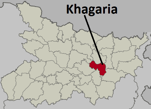
Khagaria District, located in the eastern part of Bihar, India, serves as an administrative division with its main office situated in Khagaria town. We are going to discuss about Khagaria District
About Khagaria District
History
Historically, Khagaria has deep roots dating back to ancient times when it was part of the central region of India known as Madhyadesh or Madhyabhumi. Mentioned in the Mahabharata, it was recognized as Midair, an important capital near Banga and Tamralipti.
Initially, the area fell under the jurisdiction of the Anga region, with its capital at Champa (present-day Nathnagar, Bhagalpur district), ruled by the legendary warrior Karna. The Anga region extended across modern Bhagalpur, Munger, and up to the Koshi River in the north and Purnia district in the west.
The earliest historical accounts of the region date back to the 7th century AD with the visit of Hui Shen, followed by a gap until the 9th century AD when it came under the rule of the Pal dynasty.

During the British era, Munger gained prominence in 1762 when Kasim Ali Khan shifted the capital from Murshidabad to Munger. The town was adorned with treasures, elephants, horses, and an Imambara. Kasim Ali Khan’s chief general, Gurudin Khan, organized the army and established an arms factory in Munger.
Following conflicts with the British, Munger came under British rule in 1763, marking the end of its royal existence. In 1812, Munger became a separate administrative center, dividing into five police stations by 1814.
In June 1874, significant administrative changes occurred with the transfer of several Parganas from Bhagalpur district to Munger district, expanding its jurisdiction. This included the incorporation of villages like Tapsiloda, Simarwan, and Sahuri, along with parts of Lakhnapur.

Khagaria was initially a subdivision within the Munger district before it gained district status on May 10, 1981.
The subdivision of Khagaria was established in the year 1943-44, making it the youngest subdivision in the region before India’s independence.
Other older subdivisions in the area included Munger Sadar, Begusarai, and Jamui, with Jamui being created on July 22, 1864, and Begusarai on February 14, 1870.
The decision to create Khagaria as a separate subdivision was primarily due to the challenges posed by inadequate communication infrastructure.
Historically, the region suffered from frequent floods, leading to the absence of significant historical sites due to the erosion of important locations.
According to local history, during Emperor Akbar’s reign, Raja Todarmal was tasked with surveying the area, but due to his failure, the region was excluded, leading to the adoption of the policy of “Farak Kiya,” hence the area became known as “Pharkiya Pargana.”
Geography of Khagaria District
Khagaria District spans across an area of 1,486 square kilometers (574 square miles), which is roughly comparable to Greenland’s Nares Land.
The district is surrounded by seven rivers: Ganges, Kamla Balan, Koshi, Budhi Gandak, Kareh, Kali Koshi, and Bagmati.
These rivers pose a significant challenge as they cause annual floods, resulting in substantial loss of life, property, and livestock.
The Ganges River marks the southern boundary of the district.
Khagaria experiences extreme weather conditions, characterized by scorching hot summers and bitterly cold winters.
The rainy season typically extends until October, accompanied by heavy rainfall that often leads to river overflow and widespread flooding across many areas.
Economy of Khagaria District
Khagaria, located in Bihar, India, relies primarily on agricultural production for its economy.
The district boasts fertile and alluvial land with an average elevation of 36 meters, ideal for cultivation.
Major crops cultivated in Khagaria include maize, paddy, wheat, oilseeds, and various vegetables.
Khagaria is home to a significant population of she-buffaloes, which are predominantly reared in the Pharkiya Paragna.
Many cultivators from the area send their cattle to Pharkiya Paragna for pasturage, contributing to the district’s livestock industry.
Ghee making is a renowned trade in Khagaria, with the district being particularly famous for its production of ghee.
Trade and commerce serve as the primary non-agricultural economic activities in Khagaria district.
Khagaria and Gogri Jamalpur are the two significant trade centers in the district, with food grains being the main trading item.
Additionally, there are small numbers of traders dealing in textiles, hardware, jewelry, and other commonly used items.
Khagaria holds the status of a municipality, while Gogri is designated as a notified area, although neither has seen rapid growth as townships.
Over the years, the trading community in Khagaria has somewhat dwindled, with many traders relocating to places like Begusarai, Patna, or Siliguri.
The sale of milk and milk products, particularly ghee, is another important business activity in the area, owing to the abundance of milch cattle.
Ghee making has been a traditional occupation in Khagaria, supported by the large number of she-buffaloes reared in the Pharkiya Paragna.
Dairy cooperative societies have been formed to organize and boost the milk trade, collecting raw milk from members and sending it to chilling plants for processing.
The cooperative system ensures a steady income for farmers and provides market access, although communication challenges in remote areas still limit milk production within the cooperative network.
Increasing the number of cooperative societies and expanding their membership could inject additional capital into the district’s economy, particularly benefiting small and medium farmers.
As of December 31, 1999, the membership of dairy cooperative societies stands at 7,322, with average daily milk collections ranging from 6,920 to 9,000 liters in recent years.
Demographics
According to the 2011 census, Khagaria district in Bihar, India, had a total population of 1,666,886 people.
This population is roughly equivalent to the nation of Guinea-Bissau or the US state of Idaho.
Khagaria district ranked 300th in India out of a total of 640 districts based on population.
The district has a population density of 1,115 inhabitants per square kilometre (2,890/sq mi).
Over the decade from 2001 to 2011, Khagaria experienced a population growth rate of 29.46%.
The sex ratio in Khagaria is 883 females for every 1000 males.
The literacy rate in the district stands at 60.87%.
Approximately 5.23% of the population resides in urban areas.
Scheduled Castes make up 14.83% of the population, while Scheduled Tribes account for only 0.04%.
Regarding languages, Hindi is spoken by 29.28% of the population, while Urdu is spoken by 5.90%.
The majority of the population, about 64.46%, speaks languages classified as “Others” under Hindi in the census, primarily Angika.
The regional language of Khagaria is Angika.
Tourist Places
Katyayani Asthan
Katyayani Asthan is located approximately 12 kilometers away from the district headquarters.
The site houses a temple dedicated to Mother Katyayani, along with temples dedicated to Lord Rama, Lakshman, and Maa Janki.
Devotees visit the temple for worship particularly on Mondays and Fridays.
Legend has it that sage Katyayan performed rigorous penance on the banks of the Kaushik River, now known as Koshi, and Mother Durga was pleased to be born as his daughter, hence the name Katyayani.
Around 300 years ago, the area was dense with forests until Bhakta Sripat Mahārāj purportedly saw Mother Katyayani in a dream and subsequently constructed a temple at the site under her guidance.
Constituencies
The parliamentary constituency of 25-Khagaria covers Khagaria District exclusively. Within this constituency, there are six assembly constituencies. Four of these assembly constituencies are located within Khagaria District itself. One assembly constituency lies in Saharsa District, while another is in Samastipur District.
Parliamentary Constituency of Khagaria
Constituency No Assembly Name District
76 SimriBakhtiyarpur Saharsa
140 Hasanpur Samastipur
148 Alauli Khagaria
149 Khagaria Khagaria
150 Beldaur Khagaria
151 Parbatta Khagaria
Assembly Constituency of Khagaria
Constituency No Assembly Name
148 Alauli
149 Khagaria
150 Beldaur
151 Parbatta
Administration of Khagaria
Sub-divisions
Khagaria district have two sub-divisions:
1. Khagaria
2. Gogri
Blocks
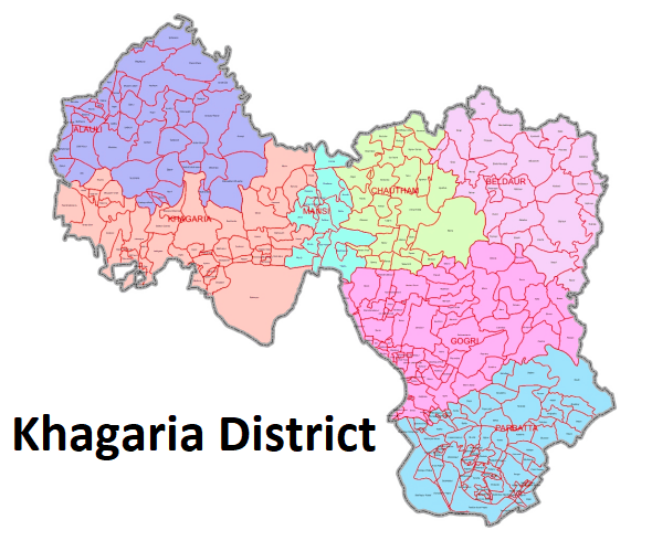
There are seven block in Khagaria district. They are follows-
- Alauli
- Khagaria
- Chautham
- Mansi
- Gogri
- Beldaur
- Parbatta
Transport
- Railways served as the main mode of communication in the district, with three railway lines passing through Khagaria.
- These railway lines included the North Eastern Railway, which had four stations: Khagaria, Mansi, Maheshkhunt, and Pasraha.
- Apart from railways, roads were another mode of communication, albeit in poor condition during that time.
- The construction of roads like the Maheshkhunt-Aguawani Ghat road and the Khagaria-Parihara-Bakhri
- Road was underway, with plans for a National Highway linking Moakamaghat to Assam.
- The area of Khagaria subdivision was prone to annual flooding due to the presence of five major rivers: the Ganga, the Gandak, the Bagmati, the Kamala, and the Koshi.
- Floods and waterlogging made communication extremely challenging, especially during the rainy season.
- Khagaria is a small town renowned for its significant railway junction on the Barauni-Guwahati section of the Indian Railways.
- The town is intersected by National Highway No. 31, serving as a crucial link between the rest of India and the North Eastern region.
- It enjoys connectivity to various parts of north Bihar via a rail line connecting it to Saharsa and Samastipur.
- A noteworthy feature is the major rail bridge over the River Ganges at Munger, facilitating direct connectivity to south Bihar and Jharkhand.
Demographics
According to the 2011 census, Khagaria district’s population stood at 1,666,886, earning it the 300th rank in India out of 640 districts.
The district exhibits a population density of 1,115 inhabitants per square kilometer (2,890/sq mi). Over the decade from 2001 to 2011, Khagaria experienced a population growth rate of 29.46%.
The sex ratio in Khagaria is reported as 883 females for every 1000 males.
The district boasts a literacy rate of 60.87%.
Urban areas house 5.23% of the total population.
Scheduled Castes constitute 14.83% of the population, while Scheduled Tribes make up only 0.04%.
Key Note
- Country -India
- State-Bihar
- Division-Munger
- Region-Mithila
- Headquarters-Khagaria
- Lok Sabha Constituencies Khagaria Lok Sabha
- Total Area 1,485 km2 (573 sq mi)
- Population (2011)Total 1,666,886
- Density 1,100/km2 (2,900/sq mi)
- Literacy 72.87 per cent
- Sex ratio 886
- Time zone UTC+05:30 (IST)
- PIN Code-8512
- Major Highways NH 31, NH 107


